Joy spread in Srinagar on Wednesday afternoon as patches of sunshine broke through the clouds, with many residents taking to social media to share relief at a pause in the downpour. Yet beneath the calm skies, experts warned that the city’s flood fate was being written far away in south Kashmir, where swollen rivers and tributaries continued to swell dangerously after relentless rain.
The situation grew more alarming by afternoon as water levels in the Jhelum and its tributaries surged sharply, with some already flowing above danger marks. Authorities and locals in south Kashmir reported inundations, damaged bridges, and livestock being moved to safety, amid fears of worsening conditions with another spell of rain forecast in the next 4–8 hours.
According to the Irrigation and Flood Control Department, the Jhelum at Sangam was flowing at 24.75 ft, just shy of the 25 ft danger mark. Pampore stood at 4.82 m, already above the 4.5 m flood declaration and nearing the 5.0 m danger level. At Ram Munshi Bagh in Srinagar, the Jhelum rose to 16.96 ft, while Asham recorded 8.59 ft and Wullar 1576.54 m.
Tributaries were also in spate. The Vishow (Weshav) Nallah at Khudwani surged to 11.20 m, well above the danger level and overflowing. Lidder Nallah touched 1.55 m, crossing the flood declaration, while Rambiyara Nallah at Wachi reached 3.90 m. The Sindh Nallah too was rising at 3.60 m, just under its alert mark.
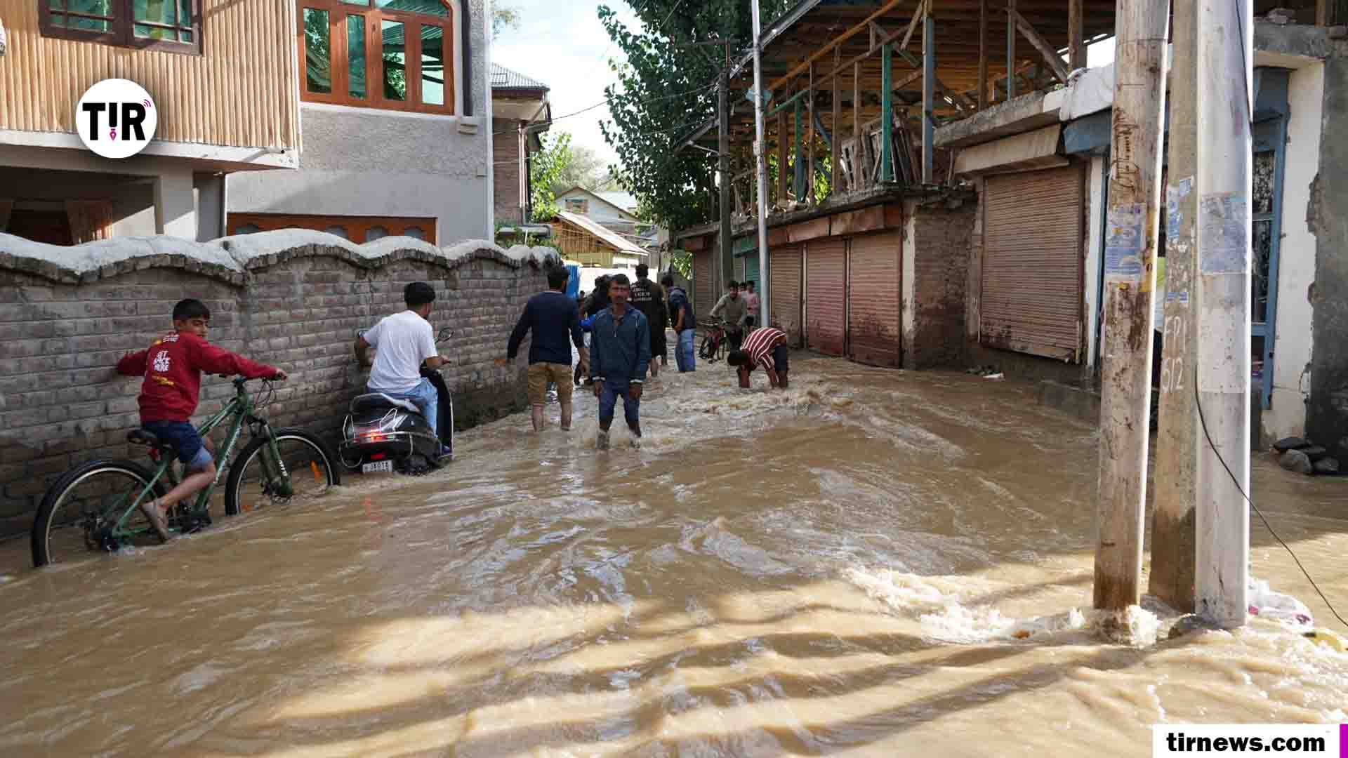
Ground reports confirmed worsening conditions in several villages. Bangidar and Mir Dantar in Anantnag were submerged by mid-morning, with police rescuing stranded families. In Arwani, Kulgam, one of the worst-hit areas during the 2014 floods, residents shifted livestock and elderly relatives to safety as the Weshav spilled into fields. “We cannot take chances after what we witnessed in 2014,” said Ghulam Rasool, a farmer from the area. In Pulwama, continuous rain since Tuesday damaged apple orchards after the Ranbiara breached its embankments. “The water has entered our orchards, and the losses will be huge,” said Bashir Ahmad, an orchardist.
Traffic was suspended on the Chagund bridge in Kulgam, while in Ara Dehurna, a partially damaged bridge forced officials to inspect the site. Authorities also ordered the closure of all schools across Kashmir as a precautionary measure.
While Srinagar itself recorded only intermittent rainfall through the day, experts caution that the city’s flood risk depends more on south Kashmir than its own skies. “For Srinagar city, whether it’s sunny or cloudy locally often doesn’t matter much in terms of flood risk. What really matters is what’s happening upstream in south Kashmir,” said Dr. A.R. Dar, a hydrology expert from Pulwama who teaches in Bangalore, while speaking to The Kashmiriyat.
Dr. Dar explained that the Jhelum originates at Verinag in south Kashmir, and most of its major tributaries – including the Lidder, Veshaw, Rambiara, Romshi, and Brengi – also come from the region. These streams carry massive volumes of water toward Sangam in Anantnag, the first key gauge point for flood monitoring. “Whatever happens in south Kashmir shows up at Sangam first. If rainfall is heavy there, the water level rises sharply, and that surge eventually moves downstream to Pampore, Srinagar, and then to north Kashmir,” Dar noted.
He described Sangam as the “thermometer” of Kashmir’s flood situation: if levels spike there, it sets off a chain reaction downstream.
He further explained the flow dynamics: “South Kashmir has steep catchment areas, so rainfall there runs off quickly into the Jhelum. By the time it reaches Srinagar, the water is concentrated and forceful. On the other hand, rainfall inside Srinagar itself doesn’t add much because the city lies in a relatively flat floodplain with a smaller catchment.”
According to Dar, this geographical contrast creates a paradox: Srinagar can appear calm, with only light showers or even sunshine, while its flood risk quietly escalates because of torrential rains further south.
He recalled the 2014 floods as a striking example. “Srinagar had not recorded extreme rainfall compared to south Kashmir. But because Sangam and upstream tributaries were overflowing, the water accumulated in Srinagar, which sits in a natural bowl-like depression. That’s why sunshine over Srinagar might look reassuring, but if it’s raining in south Kashmir, the city is still at risk.” Expanding on this, Dar said that the city’s bowl-shaped topography means floodwaters cannot easily drain once they enter.
“The water essentially has nowhere to go. If the embankments are breached or excess discharge comes from Sangam, Srinagar acts like a storage basin. That’s why people often say the fate of Srinagar is written in south Kashmir.”
Dar also stressed the role of shrinking wetlands and encroachments, which used to act as natural sponges for floodwaters. “Kashmir’s floodplains and wetlands once absorbed overflow, slowing down the surge before it reached Srinagar. But today, with massive urbanisation and filling of wetlands like Hokersar, the natural buffer is lost. This makes Srinagar even more vulnerable to any surge coming from Sangam.”
He said that unless flood channels and wetlands are restored, the city will remain exposed to repeated disasters. “We cannot control the rain, but we can control how prepared we are. Restoring natural drainage and protecting floodplains are as critical as monitoring gauges.”
_______________________________________________________________
Credit: The Kashmiriyet